The Flood Model

Despite what other creation earth scientists indicate, a sophisticated Flood model has yet to be developed. At the moment there are three main competing models. None of them are without problems so employing the principle of multiple working hypotheses is particularly useful. It allows for each idea to be sifted and refined with the hope of eventually arriving at one excellent hypothesis. The hypotheses include: 1) John Baumgardner's catastrophic plate tectonics model, 2) Walt Brown's hydroplate model, and 3) the asteroid impact model. It could be that parts of two or three of the models are correct and should be integrated into a new model. At this moment, I favor the third, but I am still doing research and gathering data.
The best approach to model building is found in 1 Thessalonians 5:21: "Examine everything carefully; hold fast to that which is good" (NASB). As I continue to examine present models, their assumptions, and as much geological, geophysical, and solar system data as possible I have concluded all of the main models have problems that need to be addressed.
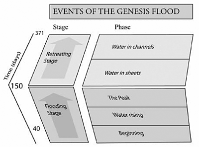
I have become convinced that the best way to understand the Genesis Flood is as a flash flood. A flash flood is a rapid rise of water as compared to a regular stream or river flood that rises slowly. A flash flood can be broken down into two stages: 1) a Flooding Stage and 2) a Retreating Stage. Within these two stages are five events: 1) a rapid initial rise, 2) a slowing of the rise, 3) the peak of the flash flood, 4) the water level falling as it flows through much of the drainage, and 5) the water levels falls exposing boulders, bars, etc. forcing the water to go around them before the flash flood is over. These stages and phases are applied to the Genesis Flood and are shown in the table developed by Tasman Walker of Australia at the third international conference on creationism in 1994.
It is my conviction we should use Tas Walker's table as the criterion to distinguish the stages and phases in the rock and fossil record. If events match those of secular scientists, as found in the geological column or parts of the geological column, so be it. But, if events do not match, it really is irrelevant. There is no reason why secular geological interpretations need to match the events of the Flood. Using Walker's chart will give researchers clear direction for a classification system.
Each of the five phases of the Genesis Flood corresponds to the five phases in a flash flood. "Water in sheets" occurs early in the Retreating Stage, since few mountains and plateaus are exposed at this time and the water is free to move across the earth as wide, fast-moving currents in places. "Water in channels" is late in the Flood after many mountains, plateaus, and other high areas become exposed causing the water to flow around these obstacles. Most of the work I have done is on these two phases of the Flood. This involves the geological subfield of geomorphology, the study of the shape of the earth's surface as well as the bottom of the ocean.
The earth's surface should display abundant evidence for the Retreating Stage of the Flood, if the Flood was an actual event. The evidence I found is very difficult to explain within the uniformitarian/actualistic model and is strong evidence for a global flood. These features include planation and erosion surfaces, tall residual remnants, water and wind gaps, pediments, the continental shelf and slope, and submarine canyons.
The Ice Age and geomorphology has revealed the most likely placement of the Flood/post-Flood boundary. Its placement is important because it gives a framework for timing late flood events as well as post Flood events. The study of geomorphology indicates the Flood runoff, the Retreating Stage, was predominantly an erosional event that covered most of the continental area. During sheet flow and erosion, the erosional debris would have been carried off of the continent to deep water where the currents slowed and dropped their load. The debris formed the continental shelf and slope, a continuous geomorphological feature that surrounds each continent. Sedimentary rocks and fossils that were left behind in most continental areas emerged from the Floodwater the quickest are from the early part of the Flood, the Flooding Stage. This indicates 95% of the sedimentary rocks were deposited early in the Flood during the Flooding Stage! This makes sense, because the early Flood was tremendously catastrophic. That is the time one would expect the greatest amount of erosion and sedimentation to have happened. The ongoing study of geomorphology is extremely promising for creation science. For more information on geomorphology and the Retreating Stage, there is in the Books/DVDs section, a book entitled: "Flood by Design: Receding Water Shapes the Earth's Surface."